EL NIÑO SUPERSIZED! Uganda Braces for Floods, Landslides as Monster Rains Loom Into 2027
KAMPALA – Uganda is staring down a potentially turbulent rainy season after the World Meteorological Organization (WMO) warned that El Niño is set to intensify into a very strong event, raising the risk of floods, landslides, extreme heat and other weather disasters into 2027.
The WMO says there is an “exceptionally high likelihood of nearly 100%” that El Niño will persist through February 2027, with the phenomenon expected to strengthen further before reaching its peak towards the end of this year.
The warning comes as Uganda prepares for increased rainfall between September and December, with the Ministry of Water and Environment forecasting near-normal to above-normal rains across most parts of the country, accompanied by warmer-than-average temperatures.
The Ministry has warned that the intensifying El Niño, combined with an expected shift to a positive Indian Ocean Dipole (IOD) around October, could enhance rainfall particularly across central, northern and eastern Uganda.
And while the rains could boost agriculture and water supplies, authorities are warning that the same downpours could unleash havoc.
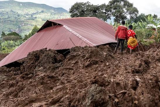
The Ministry has flagged floods, flash floods, landslides, mudslides, lightning and violent storms as major threats, particularly in the Rwenzori, Kigezi and Elgon sub-regions, the Lake Kyoga basin and parts of Kampala and other urban centres.
Several rivers have also been identified as potential flood hotspots, including Nyamwamba, Manafwa, Namatala, Kafu, Awoja and Onyama.
The rains are expected to peak between late October and November, although in some parts of Uganda they could stretch into January 2027.
The WMO warning has heightened concerns because the latest climate models point to an unusually strong El Niño developing over the tropical Pacific.
According to the UN weather agency, exceptionally warm ocean conditions are fuelling the phenomenon, with sea surface temperatures in the central and eastern equatorial Pacific already well above average and continuing to rise.
Even more extraordinary warmth has been detected beneath the ocean surface, with subsurface temperatures in some areas recorded at more than 8°C above average during July and early August.
WMO Secretary-General Celeste Saulo warned that the strengthening phenomenon could deliver a major blow to communities and economies around the world.
“El Niño in Spanish means boy child – but it has the potential to deliver a massive blow to communities and economies across the world,” Saulo said.
She warned that droughts and floods already disrupting communities could intensify as El Niño strengthens.
UN Secretary-General António Guterres was even more dramatic, saying: “El Niño is being supersized before our eyes.”
Guterres warned that rising temperatures and sea surface temperatures were placing the world in a danger zone of extreme weather, calling for urgent climate action and preparation.
For Uganda, however, the biggest immediate concern is not drought but too much water arriving too quickly.
The Ministry’s forecast indicates that the interaction between El Niño and the positive IOD could enhance rainfall, creating favourable conditions for agriculture while simultaneously increasing pressure on drainage systems, roads, bridges, homes and other infrastructure.
Urban areas such as Kampala could be particularly vulnerable to flash floods where drainage systems are overwhelmed.
Mountainous areas including Rwenzori, Kigezi and Elgon face additional risks from landslides and mudslides triggered by prolonged or intense rainfall.
The WMO has nevertheless cautioned against assuming that a very strong El Niño automatically means the same type or severity of weather everywhere.
Its impact varies by location and season and can be modified by other climate drivers, including conditions in the Indian and Atlantic Oceans.
The expected positive IOD is therefore an important piece of Uganda’s weather puzzle.
WMO forecasts indicate that the IOD could reach a seasonal mean of about 0.9°C during September-November 2026, potentially altering rainfall patterns across East Africa.
The global agency says its forecasts show an increased likelihood of above-normal temperatures across almost all land areas between September and November, while rainfall patterns are expected to reflect the atmospheric response to the strong Pacific El Niño.
The equatorial Atlantic is also expected to remain generally warm, with sea surface temperatures in both the North and South Tropical Atlantic above normal.
Scientists say these different climate drivers can reinforce, weaken or modify the typical effects associated with El Niño, making locally specific forecasts particularly important.
El Niño is one of the two opposite phases of the El Niño-Southern Oscillation (ENSO), a powerful natural climate pattern.
It occurs when ocean surface temperatures in the central and eastern equatorial Pacific become unusually warm and typically develops every two to seven years, lasting about nine to 12 months.
The phenomenon can influence weather patterns thousands of kilometres away from the Pacific, affecting rainfall and temperatures in regions far from where it originates.
For Uganda, authorities are therefore urging communities, farmers, local governments and disaster-management agencies to pay close attention to updated forecasts and early-warning information.
The WMO says national meteorological agencies remain the authoritative source of official warnings and locally relevant information.
With the rainy season approaching and El Niño expected to strengthen, Uganda now has several weeks to prepare for what could become a very wet and potentially dangerous end to 2026.
The message from climate experts is clear: the rains may bring relief to farmers and water systems, but without adequate preparation, they could also bring floods, landslides and destruction.
GOT A HOT STORY? LET US KNOW!
Got breaking news, explosive secrets, or hard evidence?
Email us: redpeppertips@gmail.com
We accept tips, documents, videos, photos, and recordings—the more evidence you have, the better.
CONFIDENTIALITY IS OUR TOP PRIORITY. SOURCES ARE ALWAYS PROTECTED!
About Post Author